
Market Analysis
Harnessing Data-Driven Satellite Imagery to Provide Stability in Volatile Markets
In today's rapidly changing world, agriculture is facing a tremendous level of uncertainty. From unpredictable weather patterns to geopolitical disruptions and economic instability, stakeholders across the agricultural supply chain are struggling to navigate these challenges.
Fortunately, data-driven insights, particularly those derived from satellite imagery, are proving to be an "ace in the hole" in terms of bringing stability to volatile markets.
The Current State of Agricultural Volatility
Agriculture has always been subject to fluctuations, but recent global events have magnified the risks, making it more difficult than ever to plan and forecast effectively. Several key factors contribute to this volatility:
Weather Extremes
Climate change has intensified the frequency and severity of extreme weather events. Prolonged droughts, unseasonal frosts, and devastating floods have disrupted planting cycles, reduced yields, and increased food insecurity. Traditional forecasting methods often fail to provide real-time insights, leaving farmers and agribusinesses reactive rather than proactive.
According to recent reports. drought shrinks soybean crops, wiping R$13bn from Rio Grande do Sul economy.
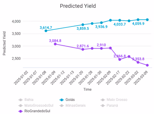
SatYield reported on March 15, 2025 the lowest yield of: 2,495.0 kg/ha in Rio Grande do Sul a with significant declines across all metrics, particularly yield (-10.35%) and production (-11.95%). While the highest yield reported: 4,058.6 kg/ha in Goiás:
Geopolitical Risks
Trade wars, tariffs, economic sanctions, and global conflicts continue to impact agricultural supply chains. For example, according to a NCGA trade study, if China reinstates tariffs, U.S. soybean exports could drop by 51.8% (14–16 million metric tons annually), while corn exports may decline by 84.3% (2.2 million metric tons annually) from expected levels. Likewise, the war in Ukraine has significantly affected global grain exports, leading to price spikes and shortages in key markets.
These uncertainties make it crucial for traders, policymakers, and agribusinesses to have access to timely and accurate data. New tariffs introduce significant risks to U.S. soybean and corn exports, potentially leading to lower prices for farmers and disruptions in global agricultural markets.
Macroeconomic Factors
Rising inflation, interest rate fluctuations, and supply chain disruptions have made input costs—such as fertilizers, seeds, and fuel—more volatile. These economic uncertainties directly affect profitability for farmers and agribusinesses, making strategic decision-making more complex.
Technological Shifts
The rise of AI, machine learning, and precision farming has revolutionized agricultural operations. However, the adoption of these technologies varies widely across different regions, leading to disparities in efficiency and production capabilities. Leveraging real-time data can help bridge this gap and enhance decision-making.
The Role of Data in Reducing Uncertainty
Traditional agricultural decision-making has long relied on historical trends, anecdotal knowledge, and intuition. But in an era where conditions change rapidly, these methods are no longer sufficient. High frequency, near real-time satellite data is transforming the way stakeholders approach agriculture by offering:
Early Detection of Crop Stress
Satellites equipped with multispectral and thermal imaging with the right tools can identify signs of crop stress—such as water deficiency—weeks before they become visible to the human eye. This early warning system allows both the farmers, agronomists and traders to take preventative action, mitigating losses before they escalate.
More Accurate Yield Forecasting
Unlike traditional forecasting methods, which often rely on outdated government reports, satellite data provides near-instantaneous insights into crop health, crop progress, and expected yields. This enables traders and agribusinesses to make informed decisions based on real-time conditions rather than historical assumptions.
Risk Mitigation for Stakeholders
With better forecasting and risk assessment tools, policymakers can develop strategies to enhance food security, traders can adjust their market positions ahead of supply shocks, and agribusinesses can optimize their procurement and distribution strategies.
How SatYield Helps Make Sense of Market Uncertainty
At SatYield, we specialize in transforming complex satellite data into actionable insights that empower stakeholders to make better decisions. Our advanced AI-driven platform provides:
Near Real-Time Insights on Crop Health
SatYield Data-fusion AI platform harnesses the power of earth observation satellites such as Sentinel-1 and Sentinel-2 to continuously scan agricultural regions, providing up-to-date information on crop conditions. This helps identify emerging risks before they impact production.
Accurate Acreage Estimates and Production Forecasts
Unlike government reports that often have a lag time of weeks or even months, SatYield delivers in-season acreage estimates and production forecasts. This allows market participants to react faster to changing conditions.
Practical Applications for Stakeholders
The Future of Agricultural Market Intelligence
The next decade will bring even greater volatility, but also more sophisticated tools to navigate it. AI-driven analytics, satellite-based monitoring, and predictive modeling will become essential components of agricultural market intelligence.
The road ahead will likely include:
At SatYield, we are committed to bridging the gap between uncertainty and opportunity. Our cutting-edge solutions empower stakeholders to make informed, data-driven decisions that enhance stability in volatile agricultural markets.
Stay Ahead in an Unpredictable Market
Uncertainty in agriculture is inevitable, but the right insights can transform unpredictability into opportunity. By leveraging SatYield's real-time data and predictive analytics, traders can adjust positions ahead of market shifts, agribusinesses can optimize supply chains, and farmers can make more informed planting and selling decisions.
Stay ahead of the curve by subscribing to our insights, requesting a demo to see our technology in action, or following us on LinkedIn and X for the latest updates on how satellite data is revolutionizing agriculture.
more from the blog
